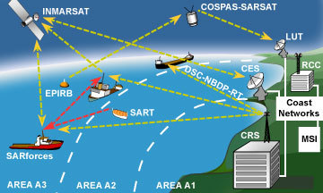
The Global Maritime Distress and Safety System (GMDSS) is an internationally agreed-upon set of safety procedures, types of equipment, and communication protocols used to increase safety and make it easier to rescue distressed ships, boats and aircraft.
GMDSS consists of several systems, some of which are new, but many of which have been in operation for many years. The system is intended to perform the following functions: alerting (including position determination of the unit in distress), search and rescue coordination, locating (homing), maritime safety information broadcasts, general communications, and bridge-to-bridge communications. Specific radio carriage requirements depend upon the ship's area of operation, rather than its tonnage. The system also provides redundant means of distress alerting, and emergency sources of power.
Recreational vessels do not need to comply with GMDSS radio carriage requirements, but will increasingly use the Digital Selective Calling (DSC) VHF radios. Offshore vessels may elect to equip themselves further. Vessels under 300 Gross tonnage (GT) are not subject to GMDSS requirements.
History
Since the invention of radio at the end of the 19th century, ships at sea have relied on Morse code, invented by Samuel Morse and first used in 1844, for distress and safety telecommunications. The need for ship and coast radio stations to have and use radiotelegraph equipment, and to listen to a common radio frequency for Morse encoded distress calls, was recognized after the sinking of the liner RMS Titanic in the North Atlantic in 1912. The U.S. Congress enacted legislation soon after, requiring U.S. ships to use Morse code radiotelegraph equipment for distress calls. The International Telecommunications Union (ITU), now a United Nations agency, followed suit for ships of all nations. Morse encoded distress calling has saved thousands of lives since its inception almost a century ago, but its use requires skilled radio operators spending many hours listening to the radio distress frequency. Its range on the medium frequency (MF) distress band (500 kHz) is limited, and the amount of traffic Morse signals can carry is also limited.
Not all ship-to-shore radio communications were short range. Some radio stations provided long-range radiotelephony services, such as radio telegrams and radio telex calls, on the HF bands (3–30 MHz) enabling worldwide communications with ships. For example, Portishead Radio, which was the world's busiest radiotelephony station, provided HF long-range services.In 1974, it had 154 radio operators who handled over 20 million words per year. Such large radiotelephony stations employed large numbers of people and were expensive to operate. By the end of the 1980s, satellite services had started to take an increasingly large share of the market for ship-to-shore communications.
For these reasons, the International Maritime Organization (IMO), a United Nations agency specializing in safety of shipping and preventing ships from polluting the seas, began looking at ways of improving maritime distress and safety communications. In 1979, a group of experts drafted the International Convention on Maritime Search and Rescue, which called for development of a global search and rescue plan. This group also passed a resolution calling for development by IMO of a Global Maritime Distress and Safety System (GMDSS) to provide the communication support needed to implement the search and rescue plan. This new system, which the world's maritime nations are implementing, is based upon a combination of satellite and terrestrial radio services, and has changed international distress communications from being primarily ship-to-ship based to ship-to-shore (Rescue Coordination Center) based. It spelled the end of Morse code communications for all but a few users, such as amateur radio operators. The GMDSS provides for automatic distress alerting and locating in cases where a radio operator doesn't have time to send an SOS or MAYDAY call, and, for the first time, requires ships to receive broadcasts of maritime safety information which could prevent a distress from happening in the first place. In 1988, IMO amended the Safety of Life at Sea (SOLAS) Convention, requiring ships subject to it fit GMDSS equipment. Such ships were required to carry NAVTEX and satellite EPIRBs by August 1, 1993, and had to fit all other GMDSS equipment by February 1, 1999. US ships were allowed to fit GMDSS in lieu of Morse telegraphy equipment by the Telecommunications Act of 1996.
Components of GMDSS
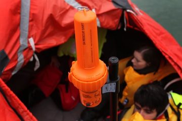
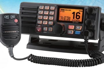
The main types of equipment used in GMDSS are:

High Frequency
<div id="panel-1298-0-0-0" class="so-panel widget widget_black-studio-tinymce …